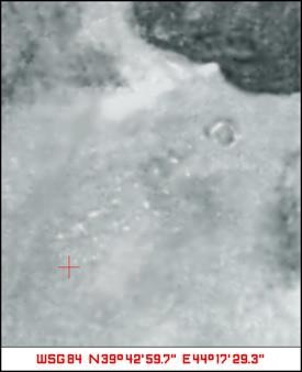
Noah's Ark has been located on Mount Ararat, though not yet excavated. It was briefly visible in 2003 after an accidental bombing incident on its northeastern end. The explosion displaced ice chunks from its gabled roof, revealing its outline. A satellite photo from that time (below) shows this. Since then, the structure has become re-covered by ice. Its approximate location is centered at 39.7176415° North, 44.2934125° East.

The northern line of ice chunks was most clearly revealed at:
In 1980, Scott Van Dyke of Houston, Texas, then a non-religious student at Washington and Lee University, experienced a vivid waking vision of discovering Noah's Ark. This vision included seeing a 15-foot hole in the structure. Inspired by this experience and subsequent encounters with Turkish eyewitnesses, Van Dyke organized a high-resolution aerial photography mission of Mount Ararat in 1989. One eyewitness suggested he look near a large "heart-shaped" object. The Ahora Gorge (the dark area in the photo) is such an object. Despite the exceptional clarity of the images, which could identify individuals on the ground, the Ark remained elusive.
Edward Crawford, a pastor and Ark enthusiast from Puyallup, Washington, conducted several expeditions to Mount Ararat. In 1990, he reportedly found a large piece of pitch-embedded timber above the tree line at the specific coordinates of 39°42’59.7” North, 44°17’29.3” East shown in the above photo. Pitch is mentioned in the Ark's construction in Genesis 6:14. He was unable to thoroughly investigate due to time constraints. Because of red tape, 17 years passed before he was able to return. Six subsequent expeditions between 2007 and 2012 failed to relocate this artifact.
In 2003, Major General Robert J. Boots provided Edward Crawford with the satellite image dated August 11, 2003, timed at 08:01:37 am. This image has undergone forensic analysis to verify its authenticity.
The 15-foot hole from Van Dyke's 1980 vision may correspond to the 2003 bomb crater, visible in the upper-right quadrant of the provided photo. The actual crater measured to about 60 feet in diameter but has since been covered by snow. The actual bomb impact point may be the disturbance at 39.718573°N, 44.295665°E (see earth.google.com).
The satellite image shows a gabled structure matching biblical descriptions and eyewitness accounts, including that of George Hagopian from the early 1900s. Distinct linear patterns of ice chunks are visible. One of the most startling aspects of the photo is that a structure similar to Biblical accounts can be clearly seen. The nine chunks along the northern length are clearly discernible as forming a straight line along the 66.6-degree bearing. The image is to be properly rotated clockwise 13.8°. A similar line of evenly-spaced disruptions (although less clear) can be seen on the southern right. These match the description of the Ark by eyewitness George Hagopian (1896-1972) who described the structure on Ararat based on two childhood expeditions with his uncle in c. 1902 (aged about 6 years) and c. 1904 (aged about 8 years).
There's speculation that Noah might have used a much larger cubit (around 117 cm as opposed to today's mere 52.3 cm for the Royal Egyptian Cubit) in constructing the Ark. This theory is based on ancient Sumerian measuring standards. This longer cubit aligns more with the photo.
While Crawford's timber discovery remains unverified and Van Dyke's photo expedition was inconclusive, the satellite image stands as the primary evidence in current Ark research. Unfortunately, many potentially valuable photos were lost due to Crawford's unexpected death on December 10, 2009, and inaccessible computer files.
Text by Zach Anderson (zmanderson@gmail.com). Placed in public domain at ultrafree.org. Feel free to copy and share, free of charge.